

CUHK
News Centre
CUHK Analyses and Evaluates Yunnan Ludian Earthquake to Help Disaster Relief Work
At 16:30:10 (GMT +8) on 3 August 2014, an earthquake of magnitude Mw6.1 hit the Ludian County of Zhaotong in Yunnan Province (according to U.S. Geological Survey, or USGS). As the Hong Kong base of the National Remote Sensing Center of China (NRSCC), the Institute of Space and Earth Information Science (ISEIS) of The Chinese University of Hong Kong (CUHK) has cooperated with NRSCC), the Academy of Opto-Electronics of the Chinese Academy of Science, the Japan Aerospace Exploration Agency (JAXA) and the Indian Space Research Organization (ISRO) to analyse and evaluate the disaster with pre-seismic and post-seismic optical and radar remote sensing images. ISEIS has sent the results to related governmental departments in Yunnan Province to support their disaster relief work and rescue operations regarding the landslide dam.
According to the earthquake mechanism providing by USGS, the magnitude of this earthquake was 6.1 on the moment magnitude scale with an intensity of up to VII (Very Strong). It was a shallow-focus-earthquake with a focus depth of only 10 km. As of 6 August, 763 aftershocks were observed. Since the epicenter of the earthquake was in the mountain area and thus it has led to many secondary disasters such as debris flows, landslides, barrier lake and epidemic, intensifying the damage to the affected region. It was reported that the earthquake had killed 617 people, injured 3,134 people, and 112 people was missing as of 8 August. Over 80,900 houses collapsed, more than 229,700 people needed to be transferred to safer places, and a total of 1,088,400 people were affected.
The professional team of CUHK ISEIS analysed the situation of the landslide dam with satellite remote sensing images captured by ALOS satellite of JAXA, RISAT-1 satellite of ISRO and GF-1 satellite of China. At present, the water level keeps rising and is threating more than ten thousand lives at downstream of Niulan River. Owing to the rainy weather, clear optical images after the shock were not available. CUHK obtained dual-polarized SAR images after the earthquake with RISAT-1 on 5 August and compared with that obtained by ALOS before the earthquake, and concluded that the surface area of Niulan River at the upper landslide dam had increased by 965,520 m² (Figure). In addition, the optical post-seismic image obtained by GF-1 clearly showed the landslide dam with a resolution of 2 meters. The findings will serve as important reference information for developing rescue plans for the landslide dam area.
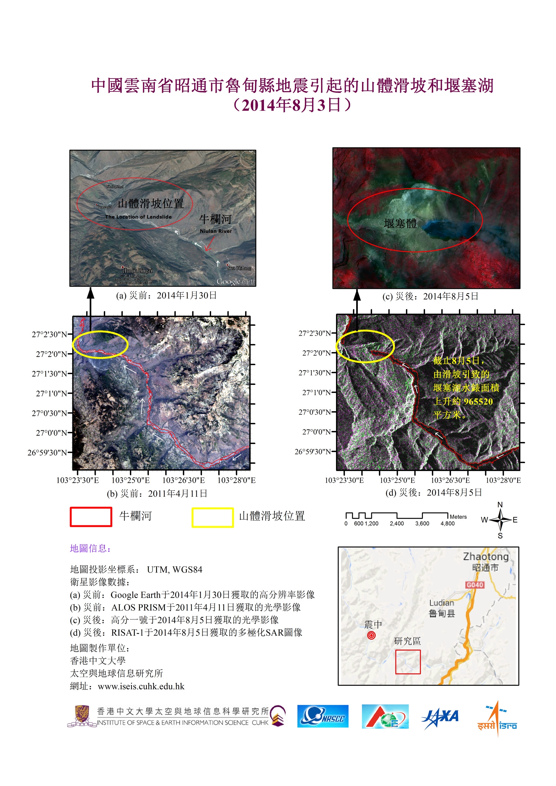
Landslide Dam (Barrier Lake) caused by the Ludian Earthquake (Chinese version)
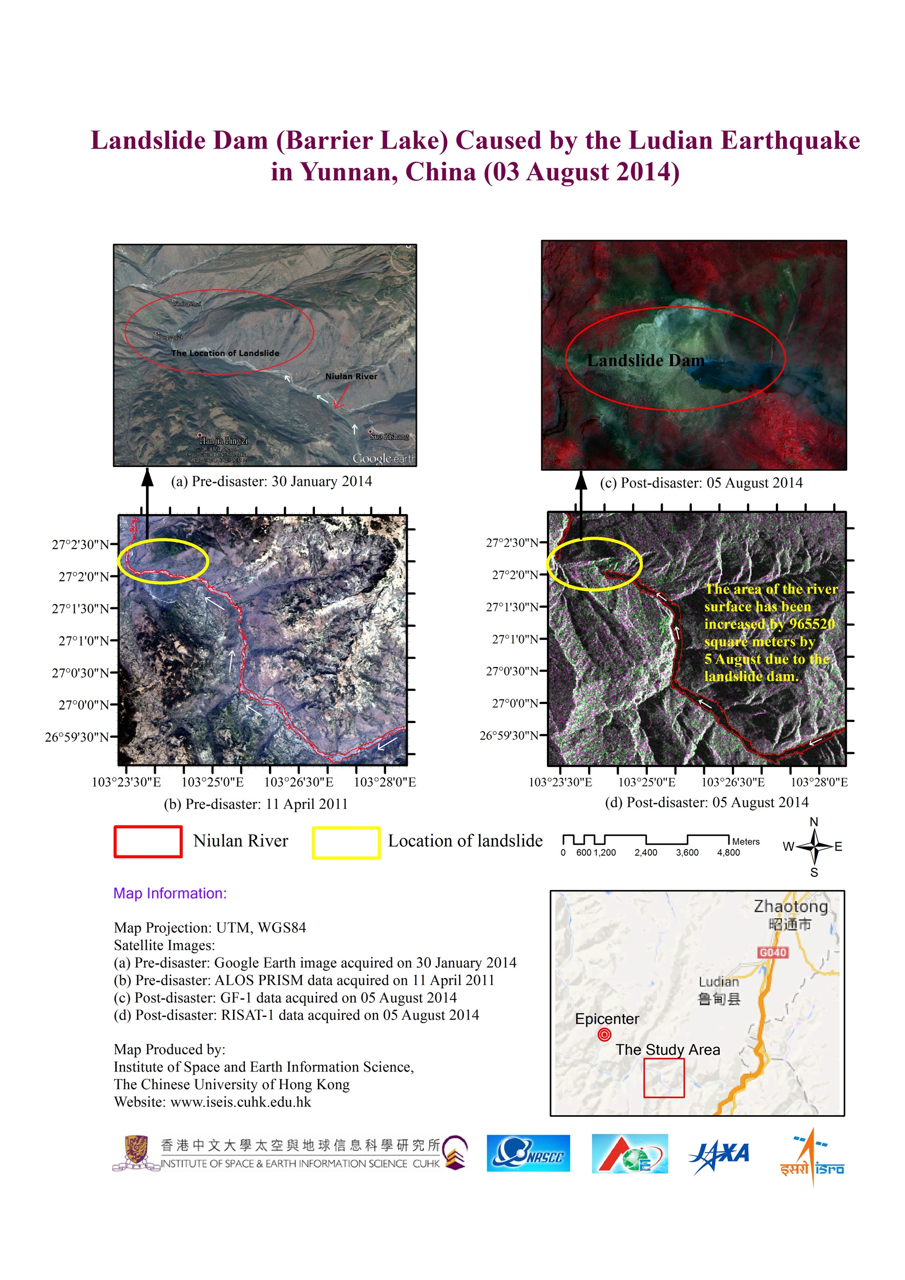
Landslide Dam (Barrier Lake) caused by the Ludian Earthquake