

CUHK
News Centre
CUHK ISEIS Makes New Progress on Radar Satellite Remote Sensing Technology for Monitoring Safety of Urban Infrastructures
A research team, led by Prof. Lin Hui, the director of the Institute of Space and Earth Information Science (ISEIS) of The Chinese University of Hong Kong (CUHK), has adopted the newly developed satellite remote sensing technology to monitor the safety of urban infrastructures and provide an early-warning service. This research project is jointly supported by the Innovation and Technology Commission (ITC) of the Hong Kong SAR Government and Hong Du (International) Development Company Ltd.
Infrastructural safety is critical to public life and property. The excessive ground and structural deformation caused by natural and/or human forces (e.g., soil/rock dissolution, underground fluid extraction, underground construction and illegal reconstruction) is threatening infrastructural safety. According to the China Geological Survey, the national economic loss induced by ground subsidence in the last 40 years was more than RMB 300 billion. A survey by the Guangdong Geological Bureau also indicated that the related direct economic loss in the Pearl River Delta region was more than RMB 10 billion at the end of 2003. In Hong Kong, reclamation, tunneling works, underground constructions and heavy loading of skyscrapers may lead to abnormal deformation. It is, therefore, necessary to regularly monitor the urban infrastructures in Hong Kong. However, the building density and the cloudy and rainy weather in Hong Kong may increase the difficulties of deformation monitoring. A novel, reliable and cost-effective method is urgently needed.
ISEIS uses synthetic aperture radar (SAR) images to constantly monitor possible deformation of urban infrastructures (e.g., buildings, highways, bridges, dams, airports, tunnels, railways, water resources systems, oil and gas pipelines) and raises alerts to the potential risks for structural safety. The satellite adopts the SAR tomography (TomoSAR), which is similar to X-ray computed tomography (CT) imaging for medical diagnosis. It can project clearer images of the urban infrastructures.
To enhance the monitoring capacity, ISEIS has developed an advanced TomoSAR-based persistent scatterer interferometry (Tomo-PSInSAR) method to monitor urban infrastructures. Tomo-PSInSAR adopts a more flexible network, robust estimators, nonlinear deformation models and super-resolution tomography. Moreover, millimetric deformation monitoring and sub-meter accuracy in a digital elevation model (DEM) can be achieved by using high-resolution images (TerraSAR-X or COSMO-SkyMed). It can effectively monitor the complex deformation of urban areas. Since there is no need to install any instrument, Tomo-PSInSAR is cost effective.
Prof. Lin Hui said, ‘The developed method can be applied to Hong Kong and be readily “exported” to other cities in the world. By regular monitoring, we can create a long-term deformation archive for the condition of urban infrastructures. The achievements can also advance scientific knowledge and people’s understanding of the dynamic mechanisms and interactions of urban infrastructures. With the rapid urbanization in China and other Asian countries, we should not neglect the potential geologic hazards and safety risks for urban infrastructures. Governments should also take the initiative in developing a deformation archive for the condition of urban infrastructures in case of any potential hazards.’
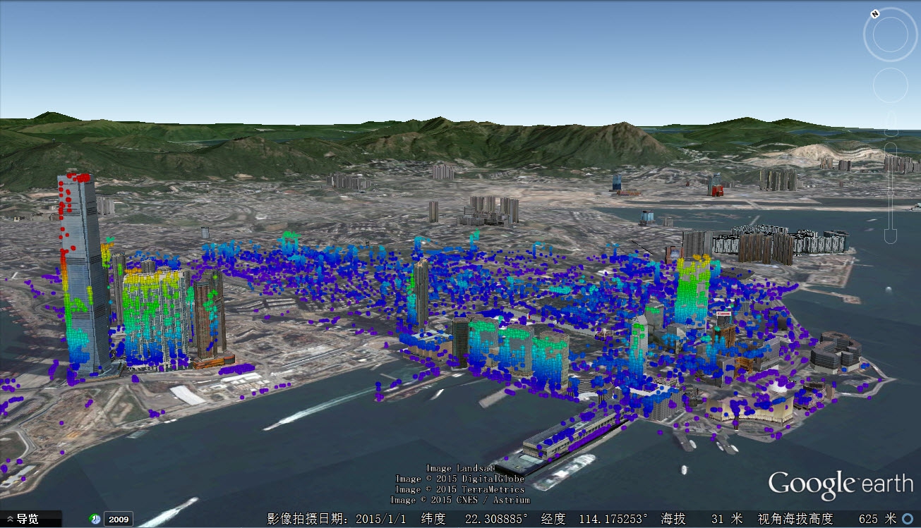
The monitoring of buildings. The color represents the height visualized in the range of (0 m (violet), 300 m (red)).
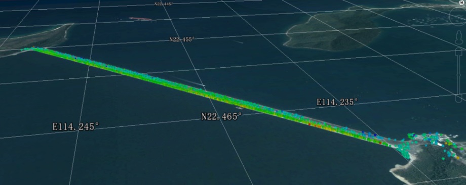
The deformation of the dam of Plover Cove Reservoir. The color represents the deformation velocity from May 2008 to March 2013 in the direction of a radar line of sight visualized in the range of (-2.5 mm/year (red), 1.5 mm/year (violet)).
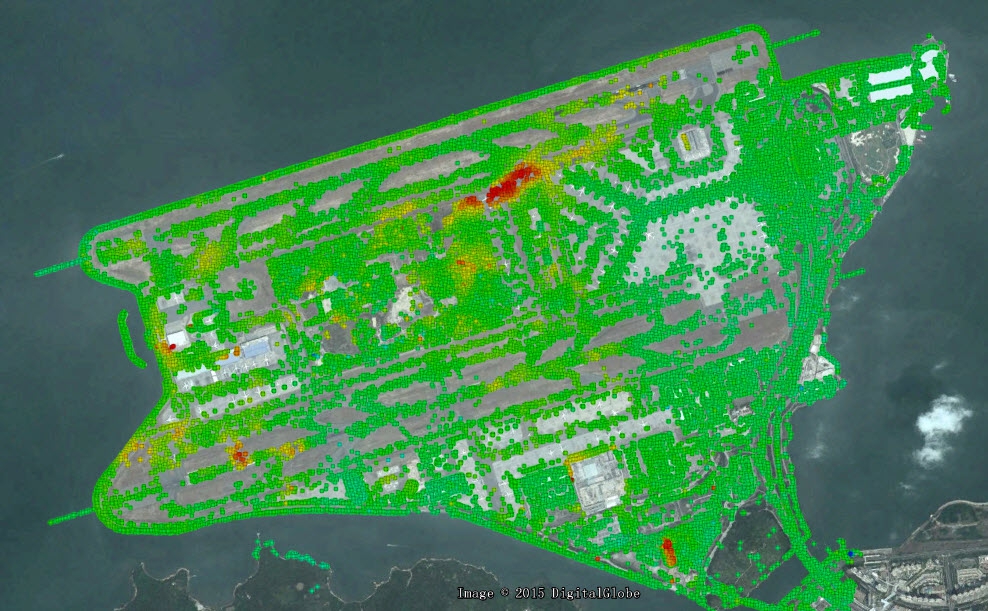
The deformation of the reclaimed Hong Kong International Airport. The color represents the deformation velocity from October 2008 to December 2009 in the vertical direction visualized in the range of (-25 mm/year (red), 25 mm/year (violet)). The corresponding 3-D settlement video is shown in “http://www.iseis.cuhk.edu.hk/eng/news/20151027.htm”.
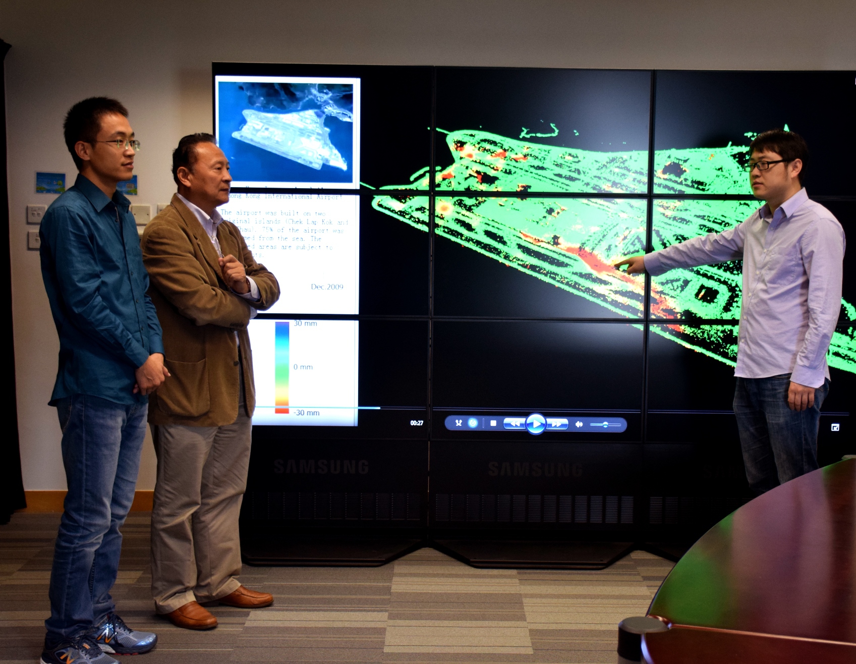
Prof. Lin Hui, the director of ISEIS, (2nd left), discusses the monitoring of the deformation of the reclaimed Hong Kong International Airport with his teammates.