
CUHK
News Centre
CUHK Achieves Breakthrough in Unified Remote Sensing Image Fusion TechnologyAdvancing Applications in Environmental and Ecosystem Monitoring
The Precision Remote Sensing Group led by Prof. Huang Bo of the Department of Geography and Resource Management and the Institute of Space and Earth Information Science (ISEIS) at The Chinese University of Hong Kong (CUHK) has developed a unified remote sensing image fusion technology that generates synthetic imagery with simultaneously high spatial, temporal, spectral, and angular (STSA) resolution to capture complex structures and changes in a dynamic, high-density urban environment like Hong Kong. It is the first time in the world that such a technology has been proposed and developed, and it represents a breakthrough in earth observation from space, contributing to more advanced applications in environmental and ecosystem monitoring. Related papers have been published in prestigious journals in the remote sensing field including IEEE Transactions on Geoscience and Remote Sensing.
The recent decades have witnessed the launch of a large number of orbiting satellite sensors with different STSA characteristics, resulting in dramatic improvements in the ability to acquire images of the Earth surface, and a boom in remote sensing (RS) applications in environmental, ecological, and disaster monitoring. However, current RS technology cannot meet the requirement of monitoring dense and dynamic urban environments with complex structures and changes that require high spatial detail, frequent coverage, fine spectral resolution, and multi-angle observation. This is largely due to the fact that there is no satellite sensor that can achieve simultaneously high STSA resolution. Current satellite RS systems compromise between spatial resolution and spectral, temporal and angular resolution, which significantly limits the applications of RS data.
The groundbreaking technology developed by Professor Huang capitalizes on the latest compressed sensing theory, sparse representation, and spatial unmixing to achieve high resolution with respect to all the image properties. The generated high STSA resolution imagery will greatly contribute to the exploration and improvement of existing satellite image resources for urban environmental applications by detecting more details in a more accurate manner. Various environmental variables such as land surface temperature, aerosol optical depth (AOD), and PM 2.5/PM 10 that can only be obtained currently in a few stations and in low spatial details will be made available through inverse modeling from the high STSA resolution satellite images to cover the whole territory of Hong Kong on a daily, monthly, quarterly and yearly basis. The new technology provides an efficient alternative to monitoring Hong Kong’s land, air, and water quality and the public can benefit from this technology by accessing environmental data (e.g. air pollution index) of any place in the territory.
Professor Huang said, ‘At present, a software package for unified remote sensing technology has been developed and a dataset for Hong Kong with high STSA resolution has been produced, which we believe will be useful to the Environmental Protection Department, Planning Department, Agriculture, Fisheries and Conservation Department, Civil Engineering and Development Department, and Hong Kong Observatory. We are confident that unified remote sensing image fusion is a particularly promising technology which holds great potential to support more applications in future as high STSA resolution imagery is in high demand by organizations related to the environment, the military, meteorology, forestry, agriculture, urban planning, transportation, oceanography, seismology etc. in government, industry and academia. We wish to seek more funds to improve and commercialize this technology.’
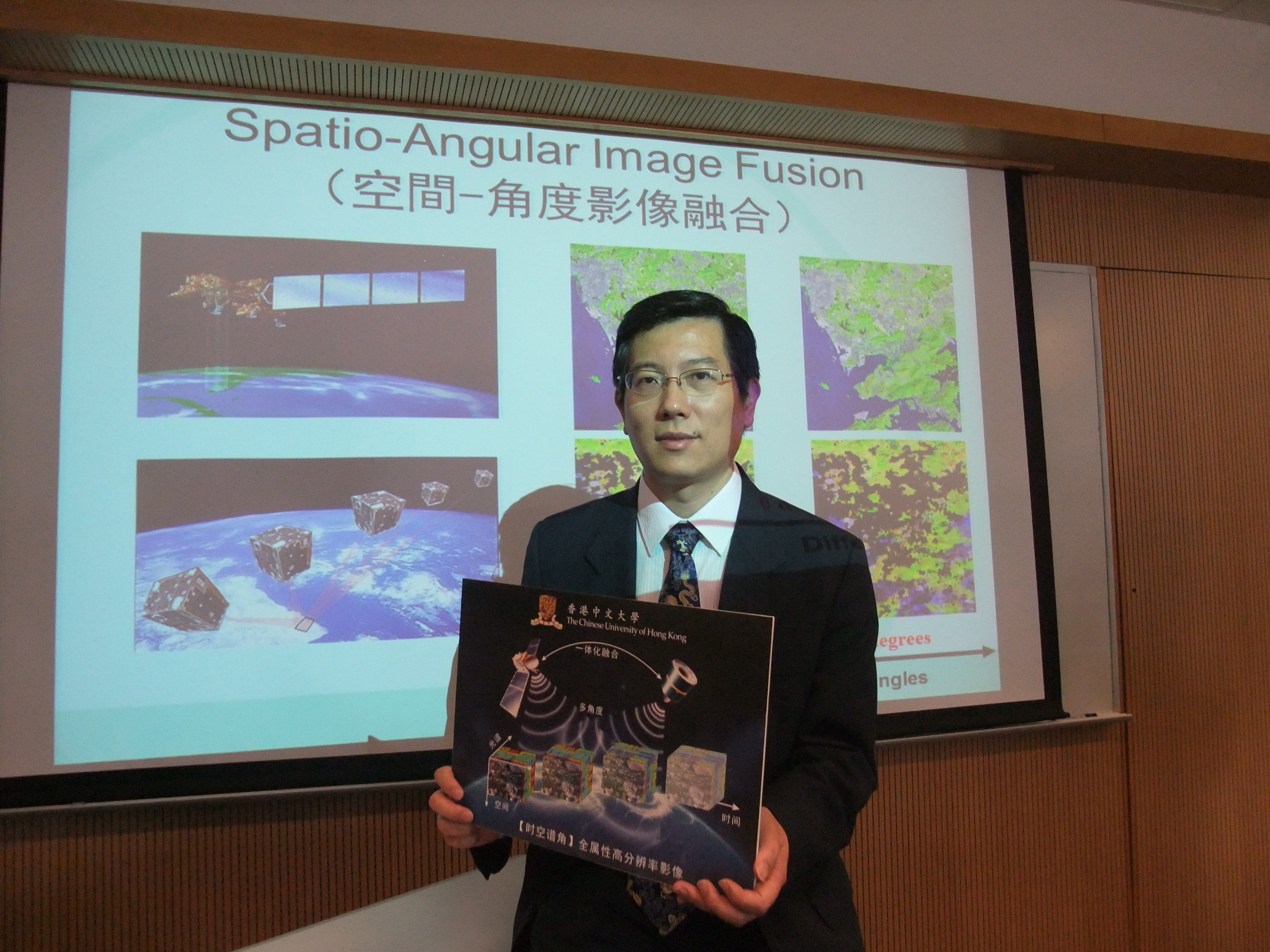
Prof. Huang Bo
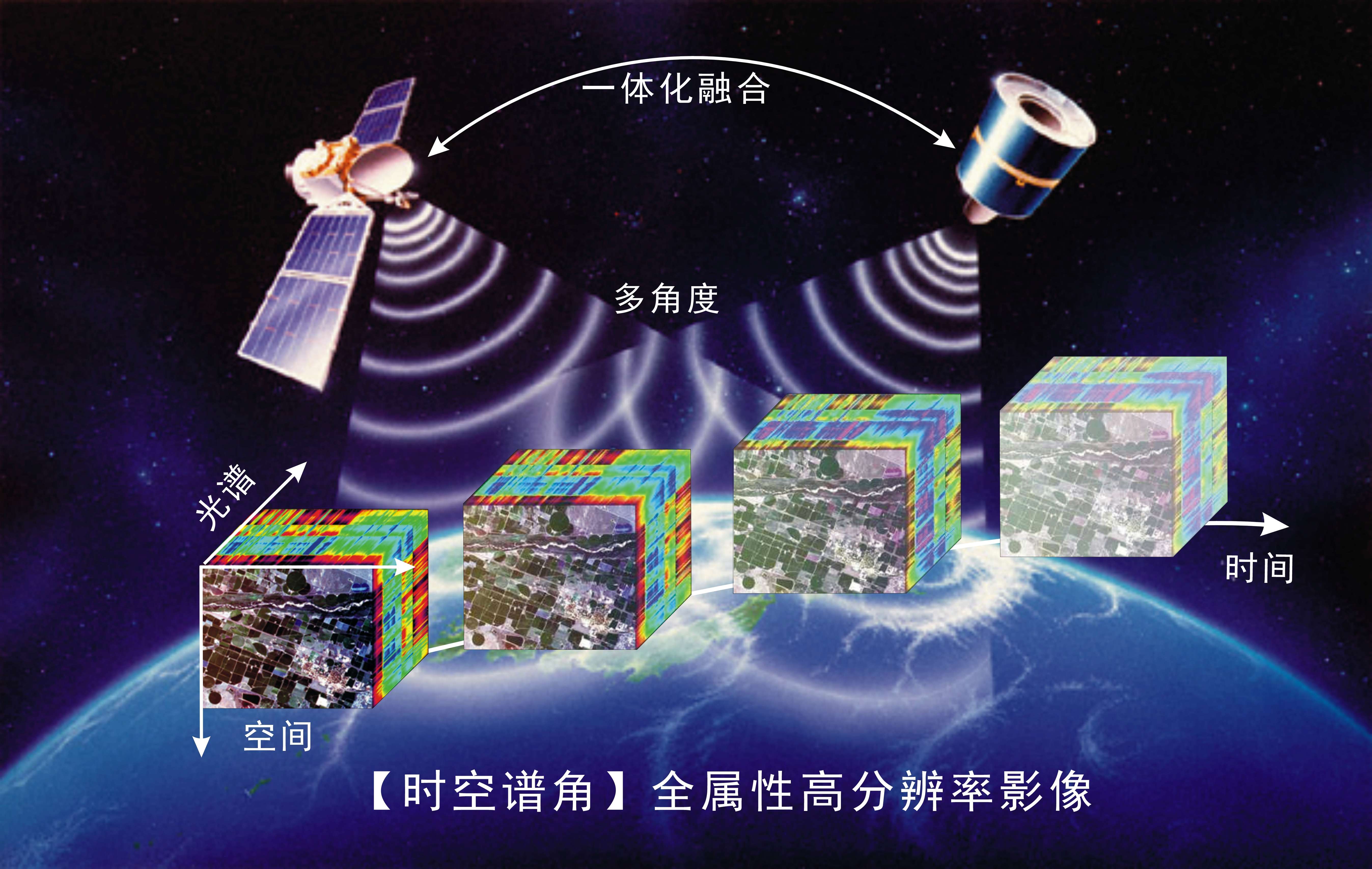
一體化遙感影像融合技術

Unified remote sensing image fusion technology